Geolocate

Jâlons topographic map

Interactive map

Click on the map to display elevation.

About this map

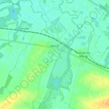
Name: Jâlons topographic map, elevation, terrain.

Location: Jâlons, Châlons-en-Champagne, Marne, Grand Est, France métropolitaine, 51150, France (48.98316 4.14988 49.03004 4.20040)

Average elevation: 79 m

Minimum elevation: 70 m

Maximum elevation: 100 m

Le territoire communal s'étend sur 10,35 km2. L'altitude varie entre 72 m, en bord de Marne, et 93 m, dans les champs au sud du village.

Wikipedia (CC-BY-SA 3.0)

Other topographic maps

Click on a map to view its topography, its elevation and its terrain.

Monthelon

France > Grand Est > Marne

Monthelon, Épernay, Marne, Grand Est, France métropolitaine, 51530, France

Average elevation: 144 m

Épernay

France > Grand Est > Marne

Épernay, Marne, Grand Est, France métropolitaine, 51200, France

Average elevation: 129 m

Athis

France > Grand Est > Marne

Athis, Épernay, Marne, Grand Est, France métropolitaine, 51150, France

Average elevation: 82 m

Reims

France > Grand Est > Marne > Reims

Reims, Marne, Grand Est, France métropolitaine, 51100, France

Average elevation: 130 m

Reims

France > Grand Est > Marne

Reims, Marne, Grand Est, France métropolitaine, 51100, France

Average elevation: 96 m