
Ilmpark topographic map
Interactive map
Click on the map to display elevation.
About this map
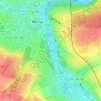
Name: Ilmpark topographic map, elevation, terrain.
Location: Ilmpark, Parkvorstadt, Weimar, Thüringen, 99425, Deutschland (50.96488 11.33011 50.98199 11.34277)
Average elevation: 243 m
Minimum elevation: 208 m
Maximum elevation: 285 m
Bemerkenswert ist auch das Haus Ithaka, das 1907 für den Dichter Ernst von Wildenbruch vom Architekten Paul Schultze-Naumburg auf einer Anhöhe oberhalb des Osthanges erbaut wurde, welches einen Blick auf den Park hatte. Diese Blickbeziehung ist jedoch ab 1997 unterhalb der Villa durch Investorenarchitektur verbaut, wie es auch mit dem Gelände um das Schießhaus nach 2013 geschah.
Other topographic maps
Click on a map to view its topography, its elevation and its terrain.
Weimar
Deutschland > Thüringen > Weimar > Weimar
Weimar, Thüringen, 99423, Deutschland
Average elevation: 282 m
99427
Deutschland > Thüringen > Weimar
99427, Weimar Nord, Weimar, Thüringen, Deutschland
Average elevation: 311 m
Schloss Tiefurt
Deutschland > Thüringen > Weimar > Tiefurt
Schloss Tiefurt, 14, Hauptstraße, Tiefurt, Weimar, Thüringen, 99425, Deutschland
Average elevation: 231 m