
Appleton topographic map
Interactive map
Click on the map to display elevation.
About this map
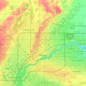
Name: Appleton topographic map, elevation, terrain.
Location: Appleton, Outagamie County, Wisconsin, United States (44.20866 -88.45158 44.35392 -88.34260)
Average elevation: 240 m
Minimum elevation: 206 m
Maximum elevation: 275 m
Other topographic maps
Click on a map to view its topography, its elevation and its terrain.
Greenville
United States > Wisconsin > Outagamie County
Greenville, Outagamie County, Wisconsin, 54942, United States
Average elevation: 258 m
Duck Creek
United States > Wisconsin > Outagamie County
Duck Creek, Outagamie County, Wisconsin, 54155, United States
Average elevation: 226 m
Kimberly
United States > Wisconsin > Outagamie County
Kimberly, Outagamie County, Wisconsin, 54136, United States
Average elevation: 225 m