
Gundeldingen topographic map
Interactive map
Click on the map to display elevation.
About this map
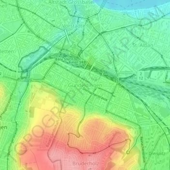
Name: Gundeldingen topographic map, elevation, terrain.
Location: Gundeldingen, Basel, Basel-Stadt, Schweiz (47.53678 7.57828 47.54959 7.60426)
Average elevation: 295 m
Minimum elevation: 249 m
Maximum elevation: 363 m
Other topographic maps
Click on a map to view its topography, its elevation and its terrain.
Kleinbasel
Schweiz > Basel-Stadt > Basel
Kleinbasel, Basel, Basel-Stadt, 4058, Schweiz
Average elevation: 261 m
Grossbasel
Schweiz > Basel-Stadt > Basel
Grossbasel, Basel, Basel-Stadt, 4002, Schweiz
Average elevation: 284 m