
Make a donation
Thessaly topographic map
Click on the map to display elevation.
Make a donation
Thessaly
The region is well delineated by topographical boundaries. The Chasia and Kamvounia mountains lie to the north, the Mount Olympus massif to the northeast. To the west lies the Pindus mountain range, to the southeast the coastal mountains of Óssa and Pelion.
Make a donation
About this map
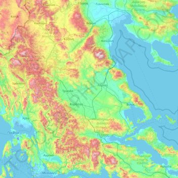
Name: Thessaly topographic map, elevation, terrain.
Location: Thessaly, Thessaly and Central Greece, Greece (38.93366 21.12042 40.19666 24.46018)
Average elevation: 454 m
Minimum elevation: -7 m
Maximum elevation: 2,747 m
Make a donation
Other topographic maps
Click on a map to view its topography, its elevation and its terrain.
Ελίτσα
Greece > Thessaly and Central Greece > Regional Unit of Magnesia > Municipal Unit of Zagora > Πουρί
Average elevation: 183 m
Fteri
Greece > Thessaly and Central Greece > Phthiotis Regional Unit > Municipal Unit of Sperchiada
Average elevation: 421 m