
Bogota, Capital District topographic map
Interactive map
Click on the map to display elevation.
Bogota, Capital District
Bogotá is located in the southeastern part of the Bogotá savanna (Sabana de Bogotá) at an average altitude of 2,640 meters (8,660 ft) above sea level. The Bogotá savanna is popularly called "savannah" (sabana), but constitutes actually a high plateau in the Andes mountains, part of an extended region known as the Altiplano Cundiboyacense, which literally means "high plateau of Cundinamarca and Boyacá". Bogotá is the largest city in the world at its elevation; there is no urban area that is both higher and more populous than Bogotá.
About this map
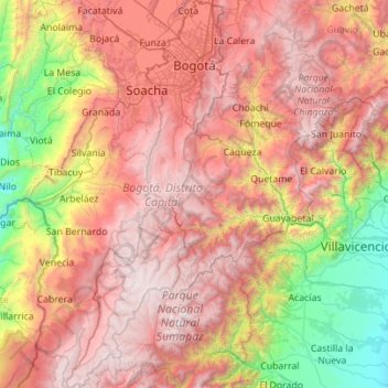
Name: Bogota, Capital District topographic map, elevation, terrain.
Location: Bogota, Capital District, RAP (Especial) Central, Colombia (3.73005 -74.45095 4.83702 -73.98590)
Average elevation: 2,183 m
Minimum elevation: 308 m
Maximum elevation: 4,222 m
Other topographic maps
Click on a map to view its topography, its elevation and its terrain.
Pacho
Pacho is a municipality and town of Colombia in the department of Cundinamarca. Pacho is part of the Rionegro Province and the urban centre is situated at a distance of 88 kilometres (55 mi) from the capital Bogotá at an altitude of 2,136 metres (7,008 ft), while the altitude ranges from 1,000 metres (3,300…
Average elevation: 1,881 m
Tunja
Tunja has a population of 172,548 inhabitants according to the 2018 Census. 0.1% of the city is indigenous, 0.4% is black, and 99.5% is white and Mestizo. It is located in central Colombia, at an elevation ranging from approximately 2,700 metres (8,900 ft) to 2,900 metres (9,500 ft). The city centre is at an…
Average elevation: 2,824 m