Geolocate

Montverde topographic map

Interactive map

Click on the map to display elevation.

About this map

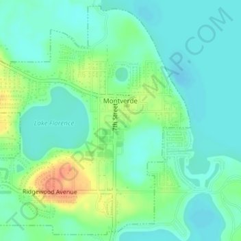
Name: Montverde topographic map, elevation, terrain.

Location: Montverde, Lake County, Florida, 34756, United States (28.58523 -81.69418 28.61090 -81.66499)

Average elevation: 27 m

Minimum elevation: 13 m

Maximum elevation: 58 m

Other topographic maps

Click on a map to view its topography, its elevation and its terrain.

Bella Collina

United States > Florida > Lake County

Bella Collina, Lake County, Florida, 34756, United States

Average elevation: 30 m

Clermont

United States > Florida > Lake County

Clermont, Lake County, Florida, 32711, United States

Average elevation: 37 m

Manhatten

United States > Florida > Lake County > Manhatten

Manhatten, Lake County, Florida, 32102, United States

Average elevation: 7 m