
Thank you for supporting this site ❤️
Make a donation
Make a donation
Erith Island topographic map
Click on the map to display elevation.
Thank you for supporting this site ❤️
Make a donation
Make a donation
About this map
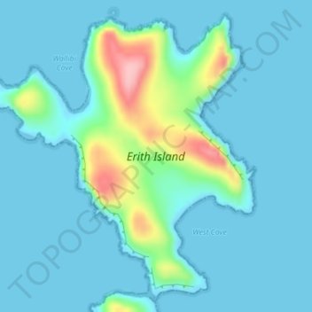
Name: Erith Island topographic map, elevation, terrain.
Location: Erith Island, Flinders Council, Tasmania, Australia (-39.46254 147.27307 -39.43813 147.30485)
Average elevation: 23 m
Minimum elevation: -1 m
Maximum elevation: 150 m
Thank you for supporting this site ❤️
Make a donation
Make a donation
Other topographic maps
Click on a map to view its topography, its elevation and its terrain.
Thank you for supporting this site ❤️
Make a donation
Make a donation
Thank you for supporting this site ❤️
Make a donation
Make a donation
Thank you for supporting this site ❤️
Make a donation
Make a donation