
Lac De Tunis topographic map
Interactive map
Click on the map to display elevation.
About this map
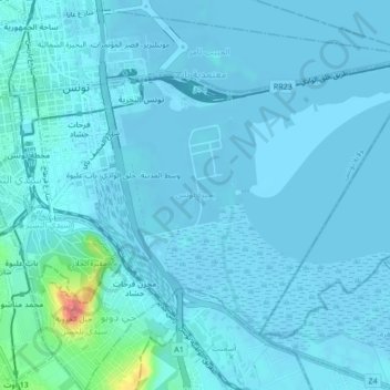
Name: Lac De Tunis topographic map, elevation, terrain.
Location: Lac De Tunis, Bab Bhar, Tunis, 1151, Tunisie (36.77853 10.18131 36.80289 10.22394)
Average elevation: 6 m
Minimum elevation: -8 m
Maximum elevation: 83 m
Other topographic maps
Click on a map to view its topography, its elevation and its terrain.
Sidi Bou Saïd
Tunisie > Tunis > Sidi Bou Saïd
Sidi Bou Saïd, Sidi Bou Said, Carthage, Tunis, 2026, Tunisie
Average elevation: 13 m
Sebkha Séjoumi
Sebkha Séjoumi, RR 39 طج, Tunis, 25 Juillet, Fouchana, Tunis, 1145, Tunisie
Average elevation: 18 m
golfe de Tunis
golfe de Tunis, Carthage, Carthage Plage, Carthage, Tunis, Tunisie
Average elevation: 30 m