
Lengkong Gudang Timur topographic map
Interactive map
Click on the map to display elevation.
About this map
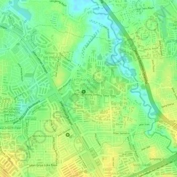
Name: Lengkong Gudang Timur topographic map, elevation, terrain.
Average elevation: 37 m
Minimum elevation: 22 m
Maximum elevation: 47 m
Other topographic maps
Click on a map to view its topography, its elevation and its terrain.
Jombang
Indonésie > Banten > Tangerang Selatan > Jombang
Jombang, Ciputat, Tangerang Selatan, Banten, Indonésie
Average elevation: 40 m