
Make a donation
Sapporo topographic map
Click on the map to display elevation.
Make a donation
Sapporo
Sapporo is a city located in the southwest part of Ishikari Plain and the alluvial fan of the Toyohira River, a tributary stream of the Ishikari River. It is part of Ishikari Subprefecture. Roadways in the urban district are laid to make a grid plan. The western and southern parts of Sapporo are occupied by a number of mountains including Mount Teine, Maruyama, and Mount Moiwa, as well as many rivers including the Ishikari River, Toyohira River, and Sōsei River. Sapporo has an elevation of 29 m (95 ft 2 in).
Make a donation
About this map
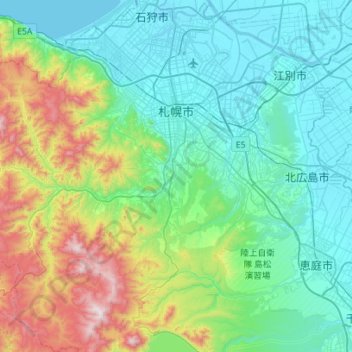
Name: Sapporo topographic map, elevation, terrain.
Location: Sapporo, Ishikari Subprefecture, Hokkaido Prefecture, Japan (42.78071 140.99050 43.18999 141.50542)
Average elevation: 273 m
Minimum elevation: -2 m
Maximum elevation: 1,299 m
Make a donation
Other topographic maps
Click on a map to view its topography, its elevation and its terrain.
Make a donation
Mt. Kumotori
Mount Kumotori (雲取山, Kumotori-san) stands at the boundary of Tokyo, Saitama, and Yamanashi Prefectures on the island of Honshū, Japan. With an elevation of 2,017 metres (6,617 ft), its summit is the highest point in Tokyo. It separates the Okutama Mountains and the Okuchichibu Mountains. While it marks…
Average elevation: 1,625 m
Make a donation