
Thank you for supporting this site ❤️
Make a donation
Make a donation
Jatiwaringin topographic map
Click on the map to display elevation.
Thank you for supporting this site ❤️
Make a donation
Make a donation
About this map
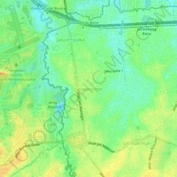
Name: Jatiwaringin topographic map, elevation, terrain.
Location: Jatiwaringin, West Java, Java, 17411, Indonesia (-6.29246 106.89474 -6.25246 106.93474)
Average elevation: 27 m
Minimum elevation: 12 m
Maximum elevation: 42 m
Thank you for supporting this site ❤️
Make a donation
Make a donation
Other topographic maps
Click on a map to view its topography, its elevation and its terrain.