
Thank you for supporting this site ❤️
Make a donation
Make a donation
Le Doulay topographic map
Click on the map to display elevation.
Thank you for supporting this site ❤️
Make a donation
Make a donation
About this map
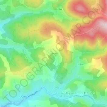
Name: Le Doulay topographic map, elevation, terrain.
Average elevation: 1,124 m
Minimum elevation: 977 m
Maximum elevation: 1,351 m
Thank you for supporting this site ❤️
Make a donation
Make a donation
Other topographic maps
Click on a map to view its topography, its elevation and its terrain.
07590
France > Auvergne-Rhône-Alpes > Ardèche > Saint-Étienne-de-Lugdarès > La Chaze
Average elevation: 1,130 m
Ruisseau de Rabeyral
France > Auvergne-Rhône-Alpes > Ardèche > Saint-Étienne-de-Lugdarès > Les Hubacs
Average elevation: 1,130 m