
Lahnkopf topographic map
Interactive map
Click on the map to display elevation.
About this map
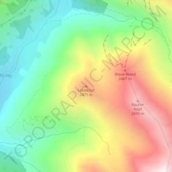
Name: Lahnkopf topographic map, elevation, terrain.
Location: Lahnkopf, Pfunds, Landeck, Tirol, 6541, Österreich (46.96915 10.62234 46.96925 10.62244)
Average elevation: 2,125 m
Minimum elevation: 1,649 m
Maximum elevation: 2,794 m
Other topographic maps
Click on a map to view its topography, its elevation and its terrain.
Via Claudia See
Österreich > Tirol > Pfunds > Gemeinde Pfunds
Via Claudia See, Reschenstraße, Gemeinde Pfunds, Bezirk Landeck, Tirol, 6542, Österreich
Average elevation: 1,326 m