
Thank you for supporting this site ❤️
Make a donation
Make a donation
Junction topographic map
Click on the map to display elevation.
Thank you for supporting this site ❤️
Make a donation
Make a donation
About this map
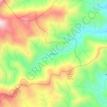
Name: Junction topographic map, elevation, terrain.
Location: Junction, Graham County, North Carolina, United States (35.24509 -83.95768 35.28509 -83.91768)
Average elevation: 1,010 m
Minimum elevation: 741 m
Maximum elevation: 1,321 m
Thank you for supporting this site ❤️
Make a donation
Make a donation
Other topographic maps
Click on a map to view its topography, its elevation and its terrain.
Lake Santeetlah
United States > North Carolina > Graham County > Lake Santeetlah
Average elevation: 635 m