
Batan Grande topographic map
Interactive map
Click on the map to display elevation.
About this map
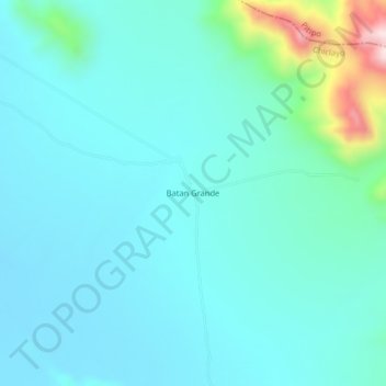
Name: Batan Grande topographic map, elevation, terrain.
Location: Batan Grande, Chongoyape, Chiclayo, Lambayeque, Perú (-6.55473 -79.56885 -6.51473 -79.52885)
Average elevation: 201 m
Minimum elevation: 132 m
Maximum elevation: 576 m
Other topographic maps
Click on a map to view its topography, its elevation and its terrain.
Reservorio de Tinajones
Perú > Lambayeque > Chongoyape
Reservorio de Tinajones, Chongoyape, Chiclayo, Lambayeque, Perú
Average elevation: 215 m
Reservorio de Tinajones
Perú > Lambayeque > Chongoyape
Reservorio de Tinajones, Chongoyape, Provincia de Chiclayo, Lambayeque, Perú
Average elevation: 215 m
Río Chancay
Perú > Lambayeque > Chongoyape
Río Chancay, Chongoyape, Provincia de Chiclayo, Lambayeque, Perú
Average elevation: 205 m