
Make a donation
Highbridge Park topographic map
Click on the map to display elevation.
Make a donation
Highbridge Park
The north and south wings respectively contain the women's and men's locker rooms and are nearly identical. Both have nine windows separated by eight brick pilasters. The stone capitals of the pilasters line up with the lintels of the windows. Ramps lead from the extreme ends of each wing. The ground slopes down northward, so that the northern wing is at a higher elevation above the ground than the southern wing. The eastern facade is similar to the western facade, except that it contains entrances to both genders' respective locker rooms, as well as a bronze clock hanging from the architrave. A cellar is below the northern wing.
Make a donation
About this map
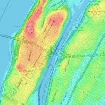
Name: Highbridge Park topographic map, elevation, terrain.
Average elevation: 30 m
Minimum elevation: -3 m
Maximum elevation: 85 m
Make a donation
Other topographic maps
Click on a map to view its topography, its elevation and its terrain.
Central Park
United States > New York > New York County > New York
In June 1856, Fernando Wood appointed a "consulting board" of seven people, headed by author Washington Irving, to inspire public confidence in the proposed development. Wood hired military engineer Egbert Ludovicus Viele as the park's chief engineer, tasking him with a topographical survey of the site. The…
Average elevation: 26 m
Inwood Hill Park
United States > New York > New York County > New York
Inwood Hill Park is a 196 acres (79 ha) public park in the Inwood neighborhood of Manhattan, New York City, operated by the New York City Department of Parks and Recreation. On a high schist ridge that rises 200 feet (61 m) above the Hudson River from Dyckman Street to the northern tip of the island, Inwood…
Average elevation: 14 m
Make a donation
Riverside Park
United States > New York > New York County > New York
Initially, Riverside Avenue had been planned to run in a straight line, which would have required a retaining wall and extensive fill. However, the area's difficult topography had come to the attention of the Manhattan park commissioners. In 1873, the commissioners selected Frederick Law Olmsted, a park…
Average elevation: 17 m
Make a donation
Make a donation
Central Park
United States > New York > New York County > New York
In June 1856, Fernando Wood appointed a "consulting board" of seven people, headed by author Washington Irving, to inspire public confidence in the proposed development. Wood hired military engineer Egbert Ludovicus Viele as the park's chief engineer, tasking him with a topographical survey of the site. The…
Average elevation: 26 m
Make a donation
Hunter’s Point South Waterfront Park
United States > New York > New York County > New York
Average elevation: 5 m