
Thank you for supporting this site ❤️
Make a donation
Make a donation
Gombaniya topographic map
Click on the map to display elevation.
Thank you for supporting this site ❤️
Make a donation
Make a donation
About this map
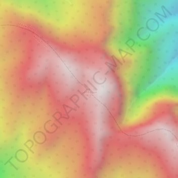
Name: Gombaniya topographic map, elevation, terrain.
Location: Gombaniya, Matale District, Central Province, Sri Lanka (7.45506 80.74824 7.45516 80.74834)
Average elevation: 1,523 m
Minimum elevation: 835 m
Maximum elevation: 1,873 m
Thank you for supporting this site ❤️
Make a donation
Make a donation
Other topographic maps
Click on a map to view its topography, its elevation and its terrain.
Thank you for supporting this site ❤️
Make a donation
Make a donation
upper division, north meddecombra
Sri Lanka > Central Province > upper division, north meddecombra
Average elevation: 1,268 m