
Thank you for supporting this site ❤️
Make a donation
Make a donation
Tirthahalli topographic map
Click on the map to display elevation.
Thank you for supporting this site ❤️
Make a donation
Make a donation
Tirthahalli
Thirthahalli is located at 13°42′N 75°14′E / 13.7°N 75.23°E / 13.7; 75.23. It has an average elevation of 591 metres (1938 feet). The Tirthahalli Town Panchayat has population of 14,528 of which 7,093 are males while 7,435 are females as per report released by Census India 2011.
Thank you for supporting this site ❤️
Make a donation
Make a donation
About this map
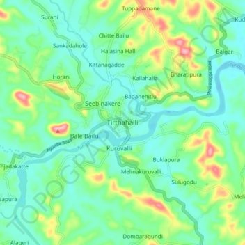
Name: Tirthahalli topographic map, elevation, terrain.
Average elevation: 635 m
Minimum elevation: 596 m
Maximum elevation: 739 m
Thank you for supporting this site ❤️
Make a donation
Make a donation