
Thank you for supporting this site ❤️
Make a donation
Make a donation
Cadillac topographic map
Click on the map to display elevation.
Thank you for supporting this site ❤️
Make a donation
Make a donation
About this map
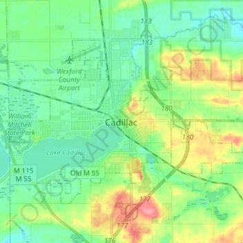
Name: Cadillac topographic map, elevation, terrain.
Location: Cadillac, Wexford County, Michigan, United States (44.22290 -85.45686 44.28128 -85.33598)
Average elevation: 405 m
Minimum elevation: 382 m
Maximum elevation: 456 m
Thank you for supporting this site ❤️
Make a donation
Make a donation
Other topographic maps
Click on a map to view its topography, its elevation and its terrain.
Lower Peninsula Experimental Forest
United States > Michigan > Wexford County > South Branch Township
Average elevation: 314 m