
Garmisch-Partenkirchen topographic map
Interactive map
Click on the map to display elevation.
About this map
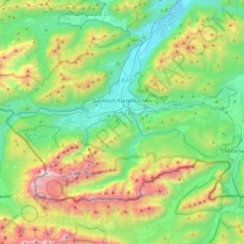
Name: Garmisch-Partenkirchen topographic map, elevation, terrain.
Average elevation: 1,322 m
Minimum elevation: 634 m
Maximum elevation: 2,952 m
Other topographic maps
Click on a map to view its topography, its elevation and its terrain.
Zugspitze
Deutschland > Bayern > Landkreis Garmisch-Partenkirchen > Grainau
Zugspitze, Grainau, Landkreis Garmisch-Partenkirchen, Bayern, 82475, Deutschland
Average elevation: 2,300 m