
Thank you for supporting this site ❤️
Make a donation
Make a donation
Northern Region topographic map
Click on the map to display elevation.
Thank you for supporting this site ❤️
Make a donation
Make a donation
About this map
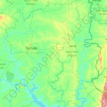
Name: Northern Region topographic map, elevation, terrain.
Location: Northern Region, Ghana (8.22848 -1.37363 10.35902 0.56700)
Average elevation: 149 m
Minimum elevation: 74 m
Maximum elevation: 853 m
Thank you for supporting this site ❤️
Make a donation
Make a donation
Other topographic maps
Click on a map to view its topography, its elevation and its terrain.
Thank you for supporting this site ❤️
Make a donation
Make a donation
Thank you for supporting this site ❤️
Make a donation
Make a donation