
Shuili Township topographic map
Interactive map
Click on the map to display elevation.
About this map
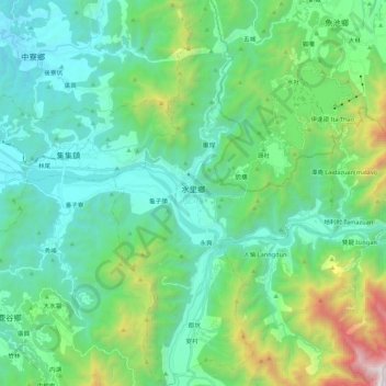
Name: Shuili Township topographic map, elevation, terrain.
Location: Shuili Township, Nantou County, Taiwan Province, Taiwan (23.71081 120.81027 23.90748 120.93695)
Average elevation: 671 m
Minimum elevation: 131 m
Maximum elevation: 2,645 m
Other topographic maps
Click on a map to view its topography, its elevation and its terrain.
Songbailun
Taiwan > Taiwan Province > Nantou County > Yuchi Township > Songbailun
Songbailun, Shuishe Village, Yuchi Township, Nantou County, Taiwan Province, 555, Taiwan
Average elevation: 772 m