
Thank you for supporting this site ❤️
Make a donation
Make a donation
Šintava topographic map
Click on the map to display elevation.
Thank you for supporting this site ❤️
Make a donation
Make a donation
Šintava
The municipality lies at an elevation of 139 metres and covers an area of 11.565 km². It has a population of about 1719 people.
Thank you for supporting this site ❤️
Make a donation
Make a donation
About this map
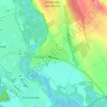
Name: Šintava topographic map, elevation, terrain.
Average elevation: 138 m
Minimum elevation: 117 m
Maximum elevation: 188 m
Thank you for supporting this site ❤️
Make a donation
Make a donation