
Rohr im Kremstal topographic map
Interactive map
Click on the map to display elevation.
Rohr im Kremstal
Rohr im Kremstal liegt auf 346 m Höhe im Traunviertel in der Mitte des fruchtbaren Kremstales, dort wo der Sulzbach in die Krems mündet. Es ist die westlichste Gemeinde des Bezirkes Steyr-Land und grenzt an die Bezirke Kirchdorf und Linz-Land. Die Ausdehnung beträgt von Nord nach Süd 6,6 km, von West nach Ost 4,9 km. Die Gesamtfläche beträgt 13,6 km². 5,9 % der Fläche sind bewaldet, 83,1 % der Fläche sind landwirtschaftlich genutzt.
About this map
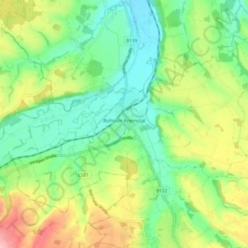
Name: Rohr im Kremstal topographic map, elevation, terrain.
Location: Rohr im Kremstal, Bezirk Steyr-Land, 4532, Österreich (48.04428 14.15001 48.08785 14.24049)
Average elevation: 367 m
Minimum elevation: 311 m
Maximum elevation: 465 m
Other topographic maps
Click on a map to view its topography, its elevation and its terrain.
Saaß
Österreich > Bezirk Steyr-Land
Der Ort Saaß befindet sich etwa 5 Kilometer südwestlich oberhalb der Stadt Steyr, halbwegs zwischen Garsten und Aschach. Er liegt direkt am Alpenrand auf der Kuppe des Saaßer Forsts (Oberfeld), auf um die 440 m ü. A. Höhe. Er zieht sich über etwa 2 km West–Ost entlang der Saaßer Straße (L1348), die…
Average elevation: 389 m