
Thank you for supporting this site ❤️
Make a donation
Make a donation
Bompensiere topographic map
Click on the map to display elevation.
Thank you for supporting this site ❤️
Make a donation
Make a donation
Bompensiere
The town is arranged along a single main street on whose sides the houses are divided, almost uniformly distributed. The lowest point of the town is to the north-west, at an altitude of about 270 meters above sea level (Piana Giarre); the highest point is located in the south-east at an altitude of about 320 meters above sea level (Contrada Portella).
Thank you for supporting this site ❤️
Make a donation
Make a donation
About this map
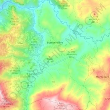
Name: Bompensiere topographic map, elevation, terrain.
Location: Bompensiere, Caltanissetta, Sicily, 93010, Italy (37.43393 13.75927 37.49893 13.81269)
Average elevation: 319 m
Minimum elevation: 154 m
Maximum elevation: 583 m
Thank you for supporting this site ❤️
Make a donation
Make a donation