
Make a donation
Witzenberg Local Municipality topographic map
Click on the map to display elevation.
Make a donation
About this map
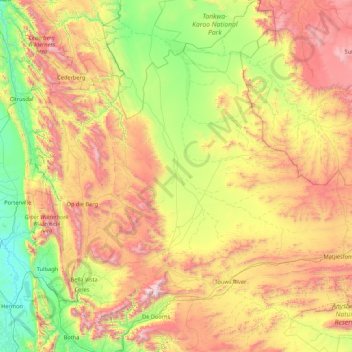
Name: Witzenberg Local Municipality topographic map, elevation, terrain.
Average elevation: 793 m
Minimum elevation: 43 m
Maximum elevation: 2,205 m
Make a donation
Other topographic maps
Click on a map to view its topography, its elevation and its terrain.
Simondium
South Africa > Western Cape > Cape Winelands District Municipality > Drakenstein Local Municipality
Average elevation: 154 m
Ceres
South Africa > Western Cape > Cape Winelands District Municipality > Witzenberg Local Municipality
Ceres experiences a typical Mediterranean climate tempered by its altitude. The town experiences warmer temperatures in summer, due to its inland location with infrequent rainfall, however winters are cool to quite cold and wet, with frequent snowfalls on the surrounding higher-lying ground, rarely falling on…
Average elevation: 586 m
Stellenbosch
South Africa > Western Cape > Cape Winelands District Municipality > Stellenbosch Local Municipality
Stellenbosch is 53 km (33 mi) east of Cape Town via National Route N1. Stellenbosch is in a hilly region of the Cape Winelands, and is sheltered in a valley at an average elevation of 136 m (446 ft), flanked on the west by Papegaaiberg (Afrikaans: Parrot Mountain), which is actually a hill. To the south is…
Average elevation: 287 m