
Thank you for supporting this site ❤️
Make a donation
Make a donation
Triora topographic map
Click on the map to display elevation.
Thank you for supporting this site ❤️
Make a donation
Make a donation
About this map
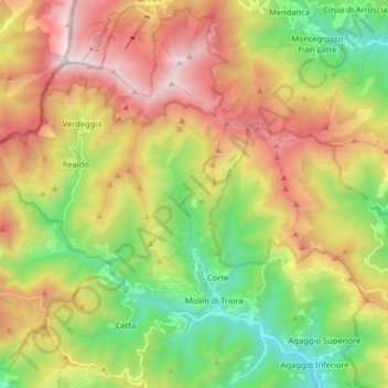
Name: Triora topographic map, elevation, terrain.
Location: Triora, Provincia di Imperia, Liguria, Italy (43.96431 7.66145 44.07986 7.77957)
Average elevation: 1,149 m
Minimum elevation: 347 m
Maximum elevation: 2,186 m
Thank you for supporting this site ❤️
Make a donation
Make a donation
Other topographic maps
Click on a map to view its topography, its elevation and its terrain.
Thank you for supporting this site ❤️
Make a donation
Make a donation
Thank you for supporting this site ❤️
Make a donation
Make a donation
Thank you for supporting this site ❤️
Make a donation
Make a donation