
Belgrade topographic map
Interactive map
Click on the map to display elevation.
About this map
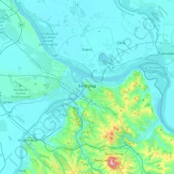
Name: Belgrade topographic map, elevation, terrain.
Location: Belgrade, City of Belgrade, Central Serbia, 11000, Serbia (44.68805 20.22138 44.94269 20.62321)
Average elevation: 108 m
Minimum elevation: 65 m
Maximum elevation: 491 m
Other topographic maps
Click on a map to view its topography, its elevation and its terrain.
Парк Луке Ћеловића
Serbia > Central Serbia > City of Belgrade > Belgrade
Парк Луке Ћеловића, Београд (Савски венац), Savski Venac Urban Municipality, Belgrade, City of Belgrade, Central Serbia, 11000, Serbia
Average elevation: 98 m