
Sanandaj topographic map
Interactive map
Click on the map to display elevation.
About this map
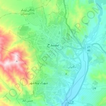
Name: Sanandaj topographic map, elevation, terrain.
Location: Sanandaj, بخش مرکزی, Sanandaj County, Kurdistan Province, Iran (35.25396 46.95646 35.35515 47.03485)
Average elevation: 1,608 m
Minimum elevation: 1,372 m
Maximum elevation: 2,353 m
Other topographic maps
Click on a map to view its topography, its elevation and its terrain.
Tappeh Now Bari
Iran > Kurdistan Province > Sanandaj County > Sanandaj
Tappeh Now Bari, Sanandaj, بخش مرکزی, Sanandaj County, Kurdistan Province, 66168-83811, Iran
Average elevation: 1,438 m
Bani Dar
Iran > Kurdistan Province > Sanandaj County > دهستان نگل > Bani Dar
Bani Dar, دهستان نگل, بخش کلاترزان, Sanandaj County, Kurdistan Province, Iran
Average elevation: 1,656 m
Avihang
Iran > Kurdistan Province > Sanandaj County > دهستان ژاورود غربی > Avihang
Avihang, دهستان ژاورود غربی, بخش کلاترزان, Sanandaj County, Kurdistan Province, Iran
Average elevation: 1,881 m