
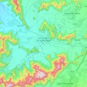
San Vicente de Tagua Tagua topographic map
Interactive map
Click on the map to display elevation.
About this map
Name: San Vicente de Tagua Tagua topographic map, elevation, terrain.
Average elevation: 348 m
Minimum elevation: 147 m
Maximum elevation: 1,199 m
Other topographic maps
Click on a map to view its topography, its elevation and its terrain.
Callejones
Chile > Região de O'Higgins > Provincia de Cachapoal > San Vicente de Tagua Tagua
Callejones, San Vicente de Tagua Tagua, Provincia de Cachapoal, Região de O'Higgins, 2970000, Chile
Average elevation: 200 m
Pelequén
Chile > Região de O'Higgins > Provincia de Cachapoal
Pelequén, Malloa, Provincia de Cachapoal, Região de O'Higgins, 2950000, Chile
Average elevation: 329 m
Pueblo de Indios
Chile > Região de O'Higgins > Provincia de Cachapoal > San Vicente de Tagua Tagua
Pueblo de Indios, San Vicente de Tagua Tagua, Provincia de Cachapoal, Região de O'Higgins, 2970000, Chile
Average elevation: 288 m
Mostazal
Chile > Região de O'Higgins > Provincia de Cachapoal > Mostazal
Mostazal, Provincia de Cachapoal, Região de O'Higgins, 2890204, Chile
Average elevation: 1,240 m