
Lubniewice topographic map
Interactive map
Click on the map to display elevation.
About this map
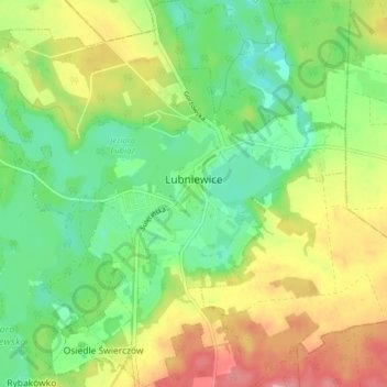
Name: Lubniewice topographic map, elevation, terrain.
Average elevation: 70 m
Minimum elevation: 28 m
Maximum elevation: 129 m
Other topographic maps
Click on a map to view its topography, its elevation and its terrain.
Wandern; See Vw.
Polen > Woiwodschaft Lebus > powiat sulęciński
Wandern; See Vw., gmina Sulęcin, powiat sulęciński, Woiwodschaft Lebus, 69-200, Polen
Average elevation: 127 m