
Jinchang topographic map
Click on the map to display elevation.
About this map
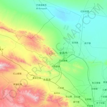
Name: Jinchang topographic map, elevation, terrain.
Location: Jinchang, Gansu, 737100, China (38.02020 101.33193 38.99771 102.72512)
Average elevation: 1,883 m
Minimum elevation: 1,330 m
Maximum elevation: 3,971 m
Other topographic maps
Click on a map to view its topography, its elevation and its terrain.
Zhangye Danxia National Geological Park
China > Gansu > Linze County > Nantai
Average elevation: 1,759 m
Mount Qilian
China > Gansu > Sunan Yugur Autonomous County > Qifeng Tibetan Ethnic Township
Average elevation: 5,071 m
Gannan
China > Gansu > Hezuo City > Tongqin
Gannan, as illustrated by this chart for Xiahe, has an alpine subarctic climate (Köppen Dwc) that grades into an alpine climate (ETH) at the highest elevations. The climate is characterised by mild, rainy summers and frigid, but dry and sunny, winters.
Average elevation: 3,075 m
Junma Sichang Qilian
China > Gansu > Shandan County > Shandan horse breeding area
Average elevation: 2,558 m