
Thank you for supporting this site ❤️
Make a donation
Make a donation
Bangor topographic map
Click on the map to display elevation.
Thank you for supporting this site ❤️
Make a donation
Make a donation
About this map
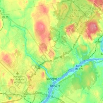
Name: Bangor topographic map, elevation, terrain.
Location: Bangor, Penobscot County, Maine, 04401, United States (44.77755 -68.85904 44.88018 -68.71874)
Average elevation: 42 m
Minimum elevation: -4 m
Maximum elevation: 99 m
Thank you for supporting this site ❤️
Make a donation
Make a donation
Other topographic maps
Click on a map to view its topography, its elevation and its terrain.
Thank you for supporting this site ❤️
Make a donation
Make a donation
Thank you for supporting this site ❤️
Make a donation
Make a donation