
Make a donation
Adams topographic map
Click on the map to display elevation.
Make a donation
Adams
The shield was derived from the Provincial Seal of Ilocos Norte. The mountain range and the verdant field and river show the topography of the place as a potential source of wealth and livelihood. The mountain ranges also symbolizes the lofty ideals and the high hopes of the people for making Adams a progressive and attractive place to live in.
Make a donation
About this map
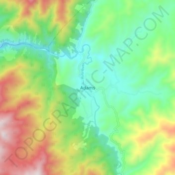
Name: Adams topographic map, elevation, terrain.
Location: Adams, Ilocos Norte, Ilocos Region, 2922, Philippines (18.42131 120.86357 18.50131 120.94357)
Average elevation: 517 m
Minimum elevation: 153 m
Maximum elevation: 1,185 m
Make a donation
Other topographic maps
Click on a map to view its topography, its elevation and its terrain.
Pagudpud
The town's topography includes mountains, hills, valleys and flat coastal land.
Average elevation: 71 m
Make a donation
Make a donation
Make a donation
La Paz Sand Dunes
Philippines > Ilocos Norte > Brgy. 62-B Navotas South > Laoag
Average elevation: 7 m
Make a donation
Make a donation
Pagudpud
The town's topography includes mountains, hills, valleys and flat coastal land.
Average elevation: 73 m