
Manapur topographic map
Click on the map to display elevation.
About this map
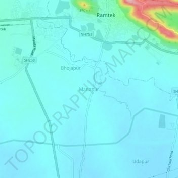
Name: Manapur topographic map, elevation, terrain.
Location: Manapur, Ramtek Taluka, Nagpur, Maharashtra, 441401, India (21.35911 79.30167 21.39911 79.34167)
Average elevation: 318 m
Minimum elevation: 299 m
Maximum elevation: 463 m
Other topographic maps
Click on a map to view its topography, its elevation and its terrain.
Ramtek Town
India > Maharashtra > Ramtek Taluka
Ramtek is located at 21°24′N 79°20′E / 21.4°N 79.33°E / 21.4; 79.33. It has an average elevation of 345 metres (1131 feet). It is located at a distance of around 50 km from Nagpur. Khindasi lake is one of the important tourist attractions at Ramtek.
Average elevation: 326 m
Pench (Indira Priyadarsini) National Park/Tiger Reserve
India > Maharashtra > Ramtek Taluka
Average elevation: 485 m