
Cheyenne topographic map
Interactive map
Click on the map to display elevation.
About this map
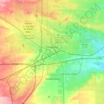
Name: Cheyenne topographic map, elevation, terrain.
Average elevation: 1,871 m
Minimum elevation: 1,803 m
Maximum elevation: 1,962 m
Other topographic maps
Click on a map to view its topography, its elevation and its terrain.
Cheyenne
Vereinigte Staaten von Amerika > Wyoming > Laramie County > Cheyenne
Cheyenne, Laramie County, Wyoming, 82002, Vereinigte Staaten von Amerika
Average elevation: 1,891 m