
Thank you for supporting this site ❤️
Make a donation
Make a donation
Lac du Forlet topographic map
Click on the map to display elevation.
Thank you for supporting this site ❤️
Make a donation
Make a donation
Lac du Forlet
Le lac des Truites, ou lac du Forlet, est le plus élevé des lacs vosgiens à 1 066 m d'altitude. Il est dénommé Forlenweier en alsacien et reïf tou blan en welsch.
Thank you for supporting this site ❤️
Make a donation
Make a donation
About this map
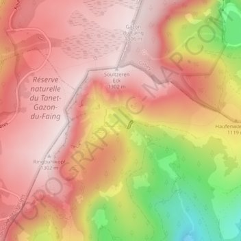
Name: Lac du Forlet topographic map, elevation, terrain.
Average elevation: 1,134 m
Minimum elevation: 802 m
Maximum elevation: 1,299 m
Thank you for supporting this site ❤️
Make a donation
Make a donation
Other topographic maps
Click on a map to view its topography, its elevation and its terrain.