
Thank you for supporting this site ❤️
Make a donation
Make a donation
Waikeria topographic map
Click on the map to display elevation.
Thank you for supporting this site ❤️
Make a donation
Make a donation
About this map
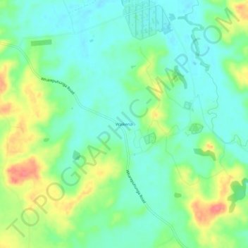
Name: Waikeria topographic map, elevation, terrain.
Location: Waikeria, Otorohanga District, Waikato, 3873, New Zealand (-38.13889 175.36252 -38.09889 175.40252)
Average elevation: 66 m
Minimum elevation: 41 m
Maximum elevation: 116 m
Thank you for supporting this site ❤️
Make a donation
Make a donation
Other topographic maps
Click on a map to view its topography, its elevation and its terrain.
Pureora Forest Park
New Zealand > Waikato > Otorohanga District
Lower altitudes are characterised by tawa and tree ferns, as well as tall native trees, including kahikatea, mataī, miro, rimu, and tōtara. The Pouakani Tōtara tree, New Zealand's tallest Tōtara, is located east of the Field Centre. The giant tōtara, rimu, mataī, miro and kahikatea trees tower 40–60…
Average elevation: 419 m