
Make a donation
Abu Dhabi Emirate topographic map
Click on the map to display elevation.
Make a donation
Abu Dhabi Emirate
The total area of the Emirate is 67,340 square kilometres (26,000 square miles), occupying about 87% of the total area of the UAE, excluding islands. The territorial waters of the Emirate embrace about 200 islands off its 700 km (430 miles) coastline. The topography of the Emirate is dominated by low-lying sandy terrain dotted with sand dunes exceeding 300 m (980 ft) in height in some areas southwards. The eastern part of the Emirate borders the western fringes of the Hajar Mountains. Hafeet Mountain, Abu Dhabi's highest elevation and sole mountain, rising 1,100–1,400 m (3,600–4,600 ft), is located south of Al-Ain City.
Make a donation
About this map
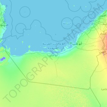
Name: Abu Dhabi Emirate topographic map, elevation, terrain.
Location: Abu Dhabi Emirate, United Arab Emirates (22.63162 51.41607 25.36383 56.01740)
Average elevation: 65 m
Minimum elevation: -15 m
Maximum elevation: 1,113 m
Make a donation
Other topographic maps
Click on a map to view its topography, its elevation and its terrain.
Dubai
Dubai lies directly within the Arabian Desert. However, the topography of Dubai is significantly different from that of the southern portion of the UAE in that much of Dubai's landscape is highlighted by sandy desert patterns, while gravel deserts dominate much of the southern region of the country. The sand…
Average elevation: 7 m
Make a donation
Make a donation
Make a donation
Make a donation
Make a donation
Make a donation
Jabal Hafeet
United Arab Emirates > Abu Dhabi Emirate > Al Ain > Jabal Hafeet
Average elevation: 610 m
Make a donation
Make a donation
Green Mubazzarah Park
United Arab Emirates > Abu Dhabi Emirate > Al Ain > Mbazzarah Al Khadra
Average elevation: 305 m
Al Ain
United Arab Emirates > Abu Dhabi Emirate > Al Ain > Al Mutaredh
Al Ain is located approximately 160 kilometres (99 mi) east of the capital Abu Dhabi, and about 120 kilometres (75 mi) south of Dubai. The eastern region covers an area of approximately 13,100 km2 (5,100 sq mi). Oman lies to the east, Dubai and Sharjah to the north, Abu Dhabi to the west and the Empty Quarter…
Average elevation: 294 m
Make a donation
Make a donation
Make a donation
Make a donation
Make a donation
Sha'biyyat Ash Shiweb
United Arab Emirates > Abu Dhabi Emirate > Al Ain > Al Shiwayb
Average elevation: 278 m
Al Fay Forest Park
United Arab Emirates > Abu Dhabi Emirate > Abu Dhabi > Abu Dhabi
Average elevation: 2 m
Hatta
Due to Hatta's higher altitude, its climate is much cooler than central Dubai. Hatta has an arid landscape and temperature, reaching 55 degrees Celsius in the summer; however, it is less humid than Dubai and far colder in the winter.
Average elevation: 371 m
Al Ain
United Arab Emirates > Abu Dhabi Emirate > Al Ain > Al Mutaredh
The city is located approximately 160 kilometres (99 mi) east of the capital Abu Dhabi, and about 120 kilometres (75 mi) south of Dubai. The eastern region covers an area of approximately 13,100 km2 (5,100 sq mi). Oman lies to the east, Dubai and Sharjah to the north, Abu Dhabi to the west and the Empty…
Average elevation: 294 m
Make a donation
Sha'biyyat As Silēmāt
United Arab Emirates > Abu Dhabi Emirate > Al Ain > Al Salamat
Average elevation: 233 m
Make a donation
Make a donation
Make a donation
Al Ain
United Arab Emirates > Abu Dhabi Emirate > Al Ain
The city is located approximately 160 kilometres (99 mi) east of the capital Abu Dhabi, and about 120 kilometres (75 mi) south of Dubai. The eastern region covers an area of approximately 13,100 km2 (5,100 sq mi). Oman lies to the east, Dubai and Sharjah to the north, Abu Dhabi to the west and the Empty…
Average elevation: 294 m
Make a donation
Sha'biyyat Al Hiyar
United Arab Emirates > Abu Dhabi Emirate > Al Ain > Al Hiyar
Average elevation: 303 m
Make a donation
Make a donation
Make a donation
Wadi Kub
United Arab Emirates > Ras al-Khaimah > Kub
In its upper course, the wadi is formed by two arms of similar length and flow, which originate at approximately an altitude of 542 m (1,778 ft); they border Al Jaroof to the east and west, respectively; and converge to the south of this town, defining the main channel, which initially follows the direction…
Average elevation: 324 m
Make a donation
Shi'bat Al Wutah
United Arab Emirates > Abu Dhabi Emirate > Al Ain > Shi'bat Al Wutah
Average elevation: 255 m
Make a donation
Hatta
Due to Hatta's higher altitude, its climate is much cooler than central Dubai. Hatta has an arid landscape and temperature, reaching 55 degrees Celsius in the summer; however, it is less humid than Dubai and far colder in the winter.
Average elevation: 371 m
Make a donation
Make a donation