
Gumtow topographic map
Interactive map
Click on the map to display elevation.
About this map
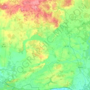
Name: Gumtow topographic map, elevation, terrain.
Location: Gumtow, Prignitz, Brandenburg, 16855, Deutschland (52.91236 12.05405 53.08192 12.41865)
Average elevation: 60 m
Minimum elevation: 28 m
Maximum elevation: 125 m
Other topographic maps
Click on a map to view its topography, its elevation and its terrain.
Wittenberge
Deutschland > Brandenburg > Prignitz
Wittenberge, Prignitz, Brandenburg, 19322, Deutschland
Average elevation: 23 m
Legde/Quitzöbel
Deutschland > Brandenburg > Prignitz > Legde/Quitzöbel
Legde/Quitzöbel, Bad Wilsnack/Weisen, Prignitz, Brandenburg, Deutschland
Average elevation: 29 m