
Thank you for supporting this site ❤️
Make a donation
Make a donation
Ukuwela topographic map
Click on the map to display elevation.
Thank you for supporting this site ❤️
Make a donation
Make a donation
About this map
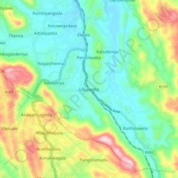
Name: Ukuwela topographic map, elevation, terrain.
Location: Ukuwela, Matale District, Central Province, 21300, Sri Lanka (7.38125 80.59318 7.46125 80.67318)
Average elevation: 483 m
Minimum elevation: 337 m
Maximum elevation: 797 m
Thank you for supporting this site ❤️
Make a donation
Make a donation
Other topographic maps
Click on a map to view its topography, its elevation and its terrain.
Thank you for supporting this site ❤️
Make a donation
Make a donation
upper division, north meddecombra
Sri Lanka > Central Province > upper division, north meddecombra
Average elevation: 1,268 m