
Thank you for supporting this site ❤️
Make a donation
Make a donation
Le Terrail topographic map
Click on the map to display elevation.
Thank you for supporting this site ❤️
Make a donation
Make a donation
About this map
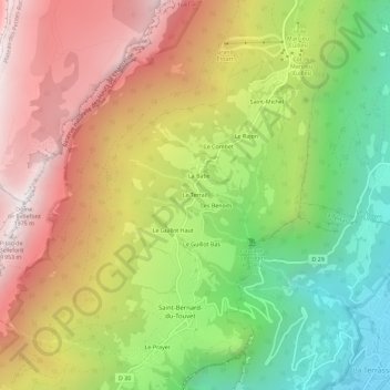
Name: Le Terrail topographic map, elevation, terrain.
Average elevation: 1,086 m
Minimum elevation: 245 m
Maximum elevation: 1,961 m
Thank you for supporting this site ❤️
Make a donation
Make a donation
Other topographic maps
Click on a map to view its topography, its elevation and its terrain.
Saint-Bernard
France > Auvergne-Rhône-Alpes > Isère > Plateau-des-Petites-Roches
Average elevation: 1,119 m
Saint-Pancrasse
France > Auvergne-Rhône-Alpes > Isère > Plateau-des-Petites-Roches
Average elevation: 1,133 m