
Liptovská Osada topographic map
Interactive map
Click on the map to display elevation.
About this map
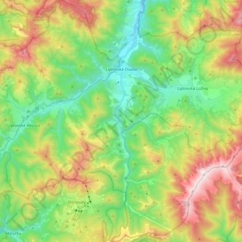
Name: Liptovská Osada topographic map, elevation, terrain.
Average elevation: 1,002 m
Minimum elevation: 565 m
Maximum elevation: 1,741 m
The municipality lies at an altitude of 609 metres and covers an area of 50.195 km². It has a population of about 1617 people.
Other topographic maps
Click on a map to view its topography, its elevation and its terrain.
Ružomberok
Slovakia > Region of Žilina > District of Ružomberok
Ružomberok, District of Ružomberok, Region of Žilina, Central Slovakia, Slovakia
Average elevation: 822 m