
Vercorin topographic map
Interactive map
Click on the map to display elevation.
Vercorin
Das Dorf liegt auf einer Bergterrasse oberhalb der Stadt Sierre auf einer Höhe von 1330 m ü. M. und hat Sicht auf das Rhonetal. Politisch gehört Vercorin zu der Gemeinde Chalais VS, wie die Dörfer Chalais und Réchy am Talrand sowie das Dorf Brie (auch Briey) ebenfalls auf der Hangterrasse.
About this map
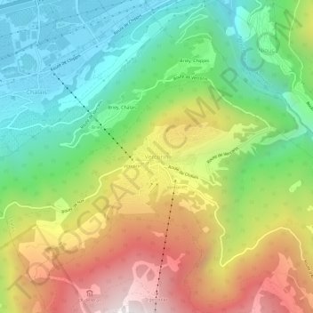
Name: Vercorin topographic map, elevation, terrain.
Location: Vercorin, Schalei, Siders, Wallis, 3967, Schweiz (46.23717 7.51070 46.27717 7.55070)
Average elevation: 1,120 m
Minimum elevation: 503 m
Maximum elevation: 2,019 m
Other topographic maps
Click on a map to view its topography, its elevation and its terrain.
Crans-Montana
Sowohl ab Sitten als auch von Siders aus führen kurvenreiche Zufahrtsstrassen von der durch das Rhônetal verlaufenden Autobahn A9. Auf 13 Kilometern wird dabei eine Höhendifferenz von 1000 Metern überwunden. Die Auffahrt durch die Rebhänge und Alpwiesen dauert von Sitten aus etwa 35, von Siders aus etwa…
Average elevation: 1,660 m