
Wuppertal topographic map
Interactive map
Click on the map to display elevation.
About this map
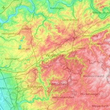
Name: Wuppertal topographic map, elevation, terrain.
Average elevation: 209 m
Minimum elevation: 40 m
Maximum elevation: 420 m
Other topographic maps
Click on a map to view its topography, its elevation and its terrain.
Schönebeck
Alemanha > Renânia do Norte-Vestfália > Wuppertal
Schönebeck, Wuppertal, Regierungsbezirk Düsseldorf, Renânia do Norte-Vestfália, 42283, Alemanha
Average elevation: 201 m