
Leeds and the Thousand Islands topographic map
Interactive map
Click on the map to display elevation.
About this map
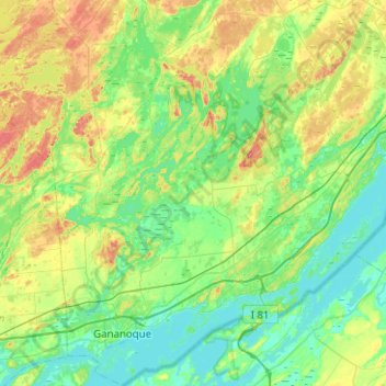
Name: Leeds and the Thousand Islands topographic map, elevation, terrain.
Average elevation: 102 m
Minimum elevation: 72 m
Maximum elevation: 185 m
Other topographic maps
Click on a map to view its topography, its elevation and its terrain.
Seeleys Bay
Canada > Ontario > Leeds and Grenville Counties > Leeds and the Thousand Islands > Seeley's Bay
Seeleys Bay, Seeley's Bay, Leeds and the Thousand Islands, Leeds and Grenville Counties, Eastern Ontario, Ontario, K0H 2N0, Canada
Average elevation: 105 m
Waterton
Canada > Ontario > Leeds and Grenville Counties > Leeds and the Thousand Islands > Waterton
Waterton, Leeds and the Thousand Islands, Leeds and Grenville Counties, Eastern Ontario, Ontario, Canada
Average elevation: 97 m