
Thank you for supporting this site ❤️
Make a donation
Make a donation
Franklin topographic map
Click on the map to display elevation.
Thank you for supporting this site ❤️
Make a donation
Make a donation
Franklin
Franklin is located at 35°10′52″N 83°22′54″W / 35.18111°N 83.38167°W / 35.18111; -83.38167 (35.181144, -83.381685). The elevation of Franklin is 2119 ft.
Thank you for supporting this site ❤️
Make a donation
Make a donation
About this map
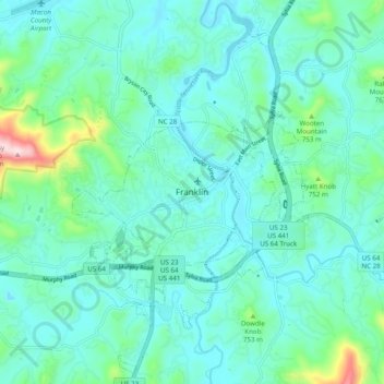
Name: Franklin topographic map, elevation, terrain.
Location: Franklin, Macon County, North Carolina, 28734, United States (35.14232 -83.42154 35.22232 -83.34154)
Average elevation: 665 m
Minimum elevation: 598 m
Maximum elevation: 997 m
Thank you for supporting this site ❤️
Make a donation
Make a donation
Other topographic maps
Click on a map to view its topography, its elevation and its terrain.
Little Tennessee River
United States > North Carolina > Macon County > Franklin > East Franklin
Average elevation: 641 m