
Thank you for supporting this site ❤️
Make a donation
Make a donation
Dinwoody Lake topographic map
Click on the map to display elevation.
Thank you for supporting this site ❤️
Make a donation
Make a donation
About this map
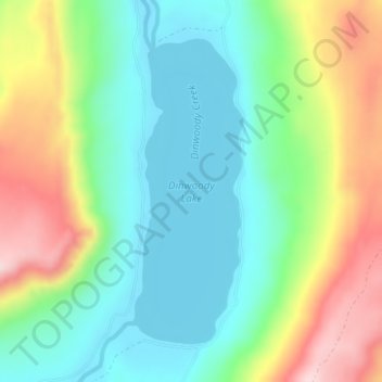
Name: Dinwoody Lake topographic map, elevation, terrain.
Location: Dinwoody Lake, Fremont County, Wyoming, United States (43.36137 -109.36891 43.38298 -109.35816)
Average elevation: 2,074 m
Minimum elevation: 1,968 m
Maximum elevation: 2,273 m
Thank you for supporting this site ❤️
Make a donation
Make a donation
Other topographic maps
Click on a map to view its topography, its elevation and its terrain.
South Pass
United States > Wyoming > Fremont County
South Pass (elevation 7,412 ft (2,259 m) and 7,550 ft (2,300 m)) is a route across the Continental Divide, in the Rocky Mountains in southwestern Wyoming. It lies in a broad high region, 35 miles (56 km) wide, between the nearly 14,000 ft (4,300 m) Wind River Range to the north and the over 8,500 ft (2,600 m)…
Average elevation: 2,295 m
Thank you for supporting this site ❤️
Make a donation
Make a donation
Thank you for supporting this site ❤️
Make a donation
Make a donation