
Make a donation
Belfast topographic map
Click on the map to display elevation.
Make a donation
About this map
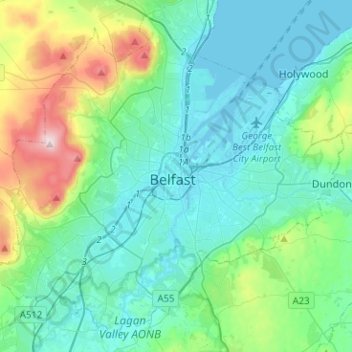
Name: Belfast topographic map, elevation, terrain.
Average elevation: 93 m
Minimum elevation: -2 m
Maximum elevation: 474 m
Make a donation
Other topographic maps
Click on a map to view its topography, its elevation and its terrain.
Ballymoney
United Kingdom > Northern Ireland > County Antrim
In 1837, Lewis's Topographical Dictionary of Ireland, describes Ballymoney as "a market-town and post-town" containing 2,222 inhabitants (11,579 in the broader civil parish) with a long established linen market chiefly supplying the London market, and with "a very extensive trade ... in grain, butter, pork,…
Average elevation: 51 m
Make a donation
Make a donation
Make a donation
Make a donation
Make a donation
Magheramorne
United Kingdom > Northern Ireland > County Antrim > Craigstown Meadow
Average elevation: 32 m
Make a donation
Make a donation
Make a donation
Make a donation
Shane's Castle Park
United Kingdom > Northern Ireland > County Antrim > Randalstown
Average elevation: 30 m
Make a donation
Make a donation
Make a donation
Make a donation
Mid and East Antrim District
United Kingdom > Northern Ireland > County Antrim
Average elevation: 111 m
Make a donation
Antrim and Newtownabbey District
United Kingdom > Northern Ireland > County Antrim
Average elevation: 97 m
Make a donation
Make a donation
Make a donation
Causeway Coast AONB
United Kingdom > Northern Ireland > County Antrim > Ballintoy
Average elevation: 34 m
Make a donation
Make a donation
Make a donation
Antrim and Newtownabbey District
United Kingdom > Northern Ireland > County Antrim
Average elevation: 97 m
Make a donation
Make a donation
Make a donation
Mid and East Antrim District
United Kingdom > Northern Ireland > County Antrim
Average elevation: 111 m
Make a donation
Antrim and Newtownabbey District
United Kingdom > Northern Ireland > County Antrim
Average elevation: 97 m
Make a donation